Figs. 1-2:
A basalt from the summit area of Eldfell, a volcanic cone which grew in a major eruption in early 1973.
Two views of this month's rock showing (left) a profile through the interior and (right) the rusty top of the piece. Sample I-4 collected (and photos 3-8 taken) on 28 July 2022.
Specimen is 13x13x10 cm in size, weight 2,429 grams. Note the flow banding and the variable size and orientation of the layers of vesicles (gas bubbles) in the basalt.
"Rock of the Month # 296, posted for February 2026" ---
A young volcanic landscape in the Vestmann Islands archipelago
Iceland, like Hawaii, is a centre of exuberant, frequent mid-ocean volcanism.
The oldest rocks in Iceland are circa 16 Ma (million years old), a geologically youthful Miocene age (for a good map of the island, see, e.g., IDNU, 2021).
Iceland lies on the Mid-Atlantic Ridge, and is a recent reminder of the formation of the North Atlantic Ocean between Greenland and Scotland, a rifting event some 60 million years in the making (the rocks of the region can be said to be in the Tertiary Volcanic District,
which includes classic geological sites in east Greenland, western Scotland and northern Ireland).
Icelandic volcanic activity in the past (historic) millennium is concentrated into a few volcanic belts and specific centres across the island. One active area is off the southwest coast, including the archipelago of the
Westmann Islands (Vestmann Islands, Vestmannaeyjar), roughly 110 km southeast of the capital, Reykjavik. The district includes the island of
Heimaey, which boasts a sheltered harbour and a lively fishing port. The nearby island of Surtsey formed the decade before the Eldfell eruption, in submarine volcanism during 1963-1967. Indeed, the whole exposed island of Heimaey is thought to have formed in the past 6,000 years.
Figs. 3-4:
The landscape of Heimaey, I ... Above: the volcanic centres of Eldfell (left, 200 m high, "Hill of Fire" in Icelandic) and the older, inactive volcano Helgafell (right, altitude 227 m), seen while walking south out of the town of Vestmannaeyjar. Below: a view from the reddened upper slopes of Eldfell, looking north towards town and harbour.
The Heimaey eruption was unexpected, and started on 23 January 1973 with the opening of activity along a 1.5-km fissure (Thorarinsson et al., 1973). Many houses were lost to falling pyroclasts (blocks of hot lava), and then in February one flank of Eldfell collapsed, allowing lava to advance on the town and port. The Icelanders sprayed the flow with seawater, stopping it less than 100 metres from the harbour. Alan Morgan of the University of Waterloo
paid numerous visits to the area over the years, and (Morgan, 2000) wrote an excellent, illustrated account of the eruption and the human aftermath (see also Williams and Moore, 1983).
The eruption ceased on 28 June, after 5 months and 5 days. The island grew in area by circa 2.2 km2,
with the addition of some 250 million m3 of volcanic products (roughly 90% lava and 10% ash).
When one thinks of eruptions it is natural to think of the obvious, dramatic effects of falling and flowing hot to molten rock. But there may also be lingering chemical fingerprints to the volcanism and associated sublimates and hot spring activity, including relatively high concentrations of unseen elements such as mercury (Coderre and Steinthorsson, 1977). For the 5,300 inhabitants, beyond the safe and efficient evacuation in the hours after the onset of eruption, a resumption of life on the island became possible surprisingly fast. One essential activity in the months of the eruption was the clearing of ash from flat roofs, since the weight, especially after rain, threatened buildings with collapse. Subsequently, the stored heat in the lava afforded a geothermal energy source in the 15 years after the eruption.
The summit of Eldfell actually fell by 18-20 metres in the 25 years after the eruption, presumably due to compaction of the summit tephra (Morgan, 2000). The story of the eruption and the subsequent compaction and erosion of volcanic products is remarkable in that landscape evolution was witnessed in a single human life span!
Figs. 5-6:
The sample location, high on Eldfell (left) and the harbour entrance (right), which survived the eruption which threatened to seal it off and ruin the local maritime economy.
Concise field guides are provided by Bamlett and Potter (1994, pp.65-68) and
Thordarson and Hoskuldsson (2014, pp.101-108). The latter note that the Vestmannaeyjar volcanic system covers some 900 km2 and includes some 80 volcanic edifices, of which 18 rise above sea level.
Volcanism across Iceland is not continuous, but rather episodic and frequent.
Sigurdsson (2016) has produced a fine little book, a colourful photographic record of the Holuhraun eruption, on the north side of the Vatnajokull ice sheet. The Bardarbunga stratovolcano, second highest peak in Iceland, under the ice sheet, awoke from dormancy in mid-August 2014, and was active until February 2015, having generated a lava field of 85 km2, the largest such event in Iceland since the historic Laki fissure eruption of 1783.
Heimaey is the southernmost and youngest of nine volcanic centres in the southward-propagating Eastern Volcanic Zone of Iceland. All the exposed subaerial volcanics on Heimaey, 10 monogenetic vents covering 13.4 km2, are of Holocene age.
Technically, the (broadly basaltic) lavas on Heimaey are hawaiite, approaching mugearite in composition (definitions are now predominantly chemical rather than mineralogical: see LeMaitre, 1989, pp.28,73,93). A magma chamber formed at 10-20 km depth, and the magma arose rapidly. Heimaey may become a central volcano, like those on the Icelandic mainland (Mattsson and Hoskuldsson, 2003).
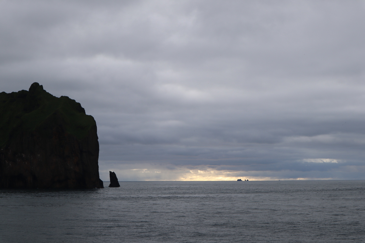
Figs. 7-8:
The landscape of Heimaey, II ... Above: a second view of the edge of town, showing how close the neighbourhood came to destruction from the northbound lavas. Below: an ocean view, southwards from the ferry returning to the Icelandic mainland, with young volcanic isles standing above the waters of the North Atlantic ocean.
REFERENCES
Bamlett,M and Potter,JF (1994) Iceland. Geologists' Association Guide no.52, ii+81pp.
Coderre,JA and Steinthorsson,S (1977) Natural concentrations of mercury in Iceland.
Geochimica et Cosmochimica Acta 41, 419-424.
IDNU (2021) Island. IDNU, Reykjavik, 19th edition, 1:500,000 scale map and 23pp. name
index booklet.
LeMaitre,RW (editor) (1989) A Classification of Igneous Rocks and Glossary of Terms. Blackwell, 193pp.
Mattsson,H and Hoskuldsson,A (2003) Geology of the Heimaey volcanic centre, south Iceland: early evolution of a central volcano in a propagating rift (?). Journal of Volcanology and Geothermal Research 127, 55-71.
Morgan,AV (2000) The Eldfell eruption, Heimaey, Iceland: a 25-year retrospective. Geoscience Canada 27, 11-18.
Sigurdsson,RT (2016) Hot Stuff: Eruption in Iceland, 2014. JPV Utgafa, Reykjavik, 84pp.
Thorarinsson,S, Steinthorsson,S, Einarsson,Th, Kristmansdottir,H and
Oskarsson,N (1973) The eruption on Heimaey, Iceland. Nature 241, 372-375.
Thordarson,T and Hoskuldsson,A (2014) Classsic Geology in Europe, 3. Iceland. Dunedin, Edinburgh, 2nd edition, xv+256pp.
Williams,RS and Moore,JG (1983) Man against volcano: the eruption on Heimaey, Vestmannaeyjar, Iceland. USGS Pamphlet 1983-381-618/103, 28pp.
Graham Wilson, 02-06 February 2026 / index: 24 April 2026
![Heimaey basalt [376 kb]](http://www.turnstone.ca/hb1.jpg)
![Heimaey basalt [364 kb]](http://www.turnstone.ca/hb2.jpg)
![Heimaey basalt [465 kb]](http://www.turnstone.ca/hb3.jpg)
![Heimaey basalt [559 kb]](http://www.turnstone.ca/hb4.jpg)
![Heimaey basalt [733 kb]](http://www.turnstone.ca/hb5.jpg)
![Heimaey basalt [602 kb]](http://www.turnstone.ca/hb6.jpg)
![Heimaey basalt [636 kb]](http://www.turnstone.ca/hb8.jpg)